

More Top Stories


Tapaitau appeal dismissed
17 July 2024

Challenging ‘rape culture’
8 July 2024

Ruta Mave: Can you trust your government?
22 July 2024


TB cases detected
1 June 2024


Touch trio ready for World Cup
23 May 2024


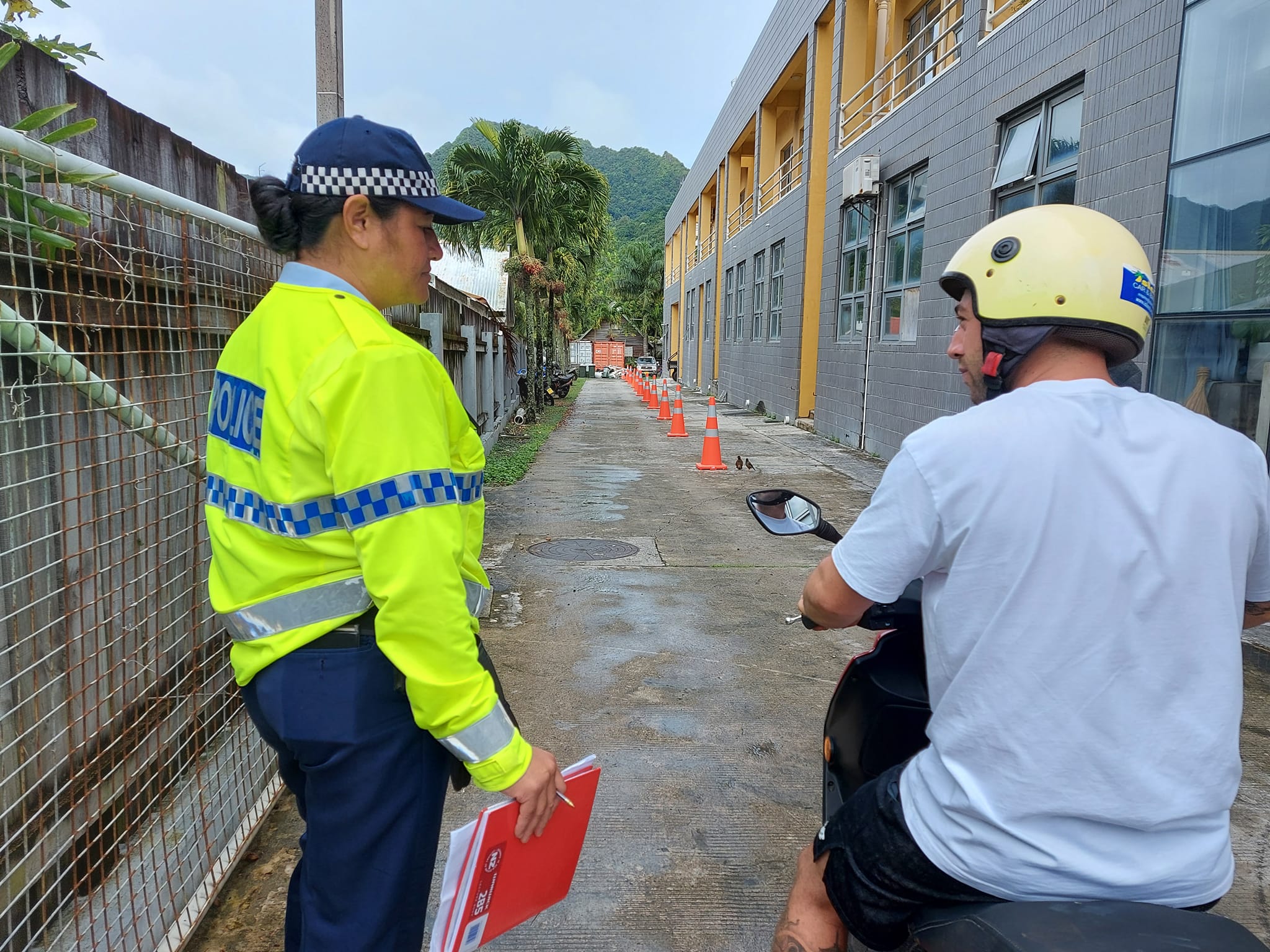
Man accused of raping minors face more charges
30 May 2024


‘Budget prioritises vulnerable’
16 May 2024


Alleged rapist in remand
27 April 2024

Rarotonga residents push back on water tariff plan
12 April 2024
Solar power battery repairs ‘could take up to 12 months’
15 April 2024
Cook Islands poised for highest Pacific growth
29 April 2024
Ex-DPM appeals ‘excessive sentence’, hearing date set
26 April 2024

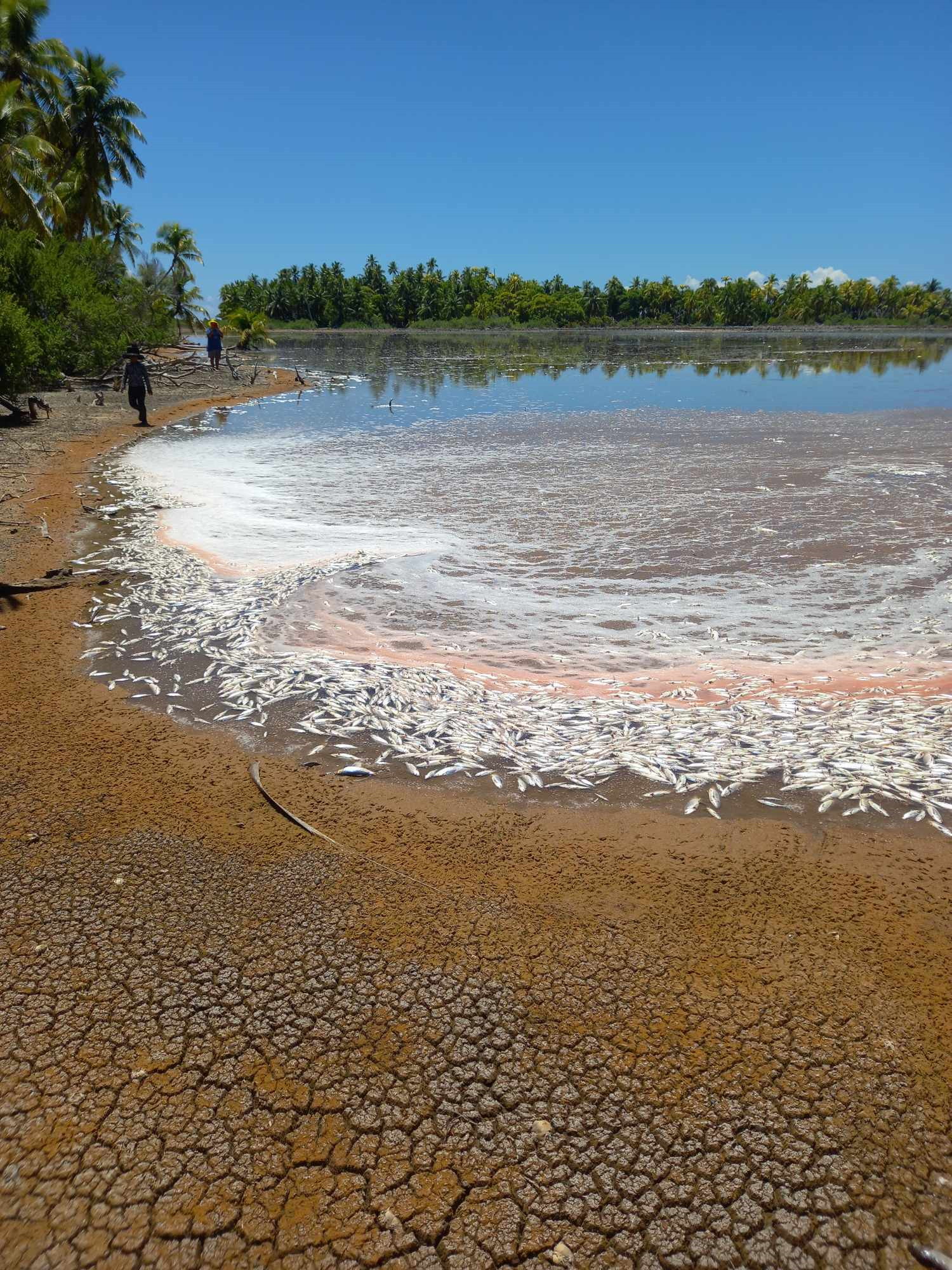
Mass milkfish die-off in Penrhyn raises concerns
3 April 2024

Regulator defends Starlink users
9 April 2024


Cook Islands set to play in new World Series
10 October 2023


Corruption report exposes ‘bribe and sexual favours’
17 January 2023

Moana target 2025 World Cup
11 November 2022
The Cook Islands that vanished?
Saturday 25 March 2023 | Written by Rod Dixon | Published in Features, Weekend
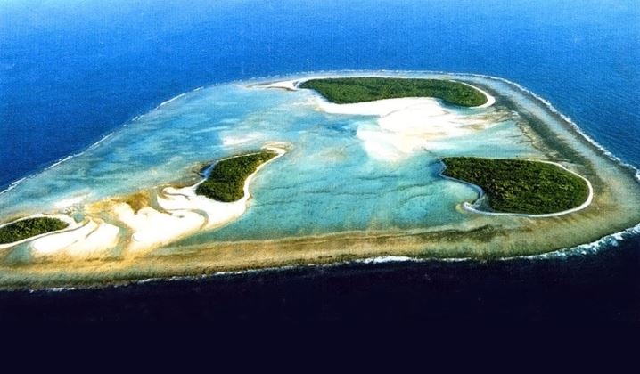
Ngaruroto also known as Îles Maria and Hull Island, part of the Austral Group, was once a food reserve and holiday resort for the people of Mauke, Rimatara and possibly Mangaia. 23032412
If historical sources are to be believed, at least three islands in the Cook Islands have vanished into thin air. One of these, Tuanaki, is said to have submerged with all its occupants, as recently as 1842. By Rod Dixon.
A Tahitian trader, Edward Lucett in Rovings in the Pacific from 1837-49 reported that people on Mauke spoke of an island called ‘Narurotu’ of which they no longer knew the location. “Their ancestors used occasionally to resort thither to fish as it possesses a lagoon in its centre, the only crater island in the group. They have only traditional accounts respecting it, as no native living on Mauke has ever seen it… I have learnt from a person who had visited the island more than once that its true position is 210 45’S and longitude 1550 10’ W. It is not inhabited, although there are plenty of cocoa-nut trees upon it.”
The location given by Lucett in fact approximates to that of Îles Maria (21° 48’S, 154° 41’ W) also known as Hull Island, part of the Austral Group. The ancient name of Îles Maria is Nororotu.
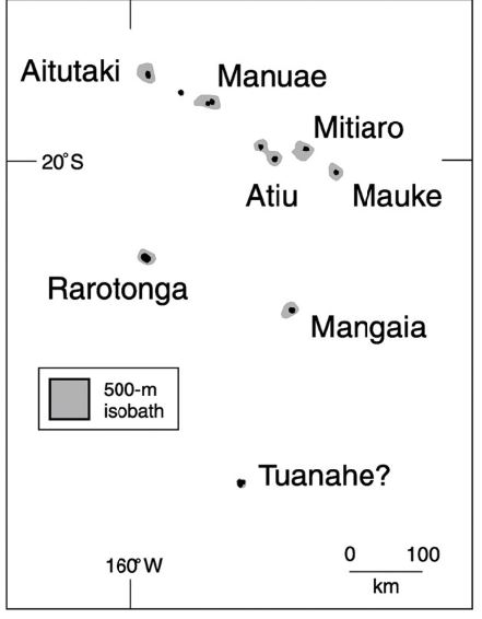
Map of the Cook Islands showing likely location of the island of Tuanaki or Tuanahe, south of Mangaia (Nunn, 2007)/ 23032410
‘Narurotu’ (or Ngaruroto) is thus not a vanished island but one of the Australs which Maukeans historically voyaged 329 km SE to harvest and holiday on. By the mid-nineteenth century, for some reason – presumably a reduced dependence on it resources – the Maukeans could no longer locate it.
It seems Ngaruroto is not so much a ‘lost island’ as an island whose location was lost from memory.
A second island, Victoria Island, was said to be located north of Tongareva.
Julian Dashwood, in an article written in 1936, claimed to have the diary of an Englishman called William Oliver who was hired to manage Victoria island which was said to be rich in guano. Oliver set sail in March 1865 from Melbourne for Aitutaki, leaving there “to hunt for Victoria Island, which the captain said was about 1000 miles distant. After a fortnight Captain Murphy said we were near the island, and he sent a man aloft to look but no land was sighted…
“About 9am, the Captain and Mate took (bearings from) the sun and, working out the reckoning, declared that we had sailed right over the island. There were thousands of birds hovering around and most of us concluded that the island had gone down in that dreadful
hurricane that had done so much damage in Aitutaki. However, we ploughed the ocean for 100 miles in all directions but no land was to be seen…”
William Marsters II claimed to have worked on Victoria Island in the 1880s planting coconuts with a labour gang from Fiji. The firm they were working for went bust, leaving them stranded on the island for eighteen months. Marsters described Victoria Island as volcanic and well forested.
In 1885, the Pacific Pilot placed Victoria Island at 6045’ S, 160042’ W but considered its existence as “very doubtful”. Patrick Nunn reports the island was marked in the 1932 edition of Phillips Atlas of the World at 5 S 164 W some 800 km NNW of Tongareva.
In early 1921, Captain Andy Thomson sailed the Tagua over the spot where the island had been marked on early charts. There was no sign and a search over a wide area failed to reveal it. Again, in 1923, Robert Dean Frisbie set out to look for the island but failed to find anything.
The island of Tuanaki (also written as Tuanahe) appears in New Zealand Maori tradition “as visited by (the migrating Maori) … and (they) also speak of it as a resting or calling place on their voyage to New Zealand. Motutapu, Poraroa, Tohua and Tuanaki were names given by a Kaipara chief (Makoare) as being all in one group, which was visited by their canoe Mahuhu on the voyage from Hawaiki.”
The Rarotongan historian Te Ariki Tara’are records a tradition which includes a man called Tama-kake-tua-ariki, who lived at Akaoa, Arorangi in the 14th century and voyaged to Tuanaki.
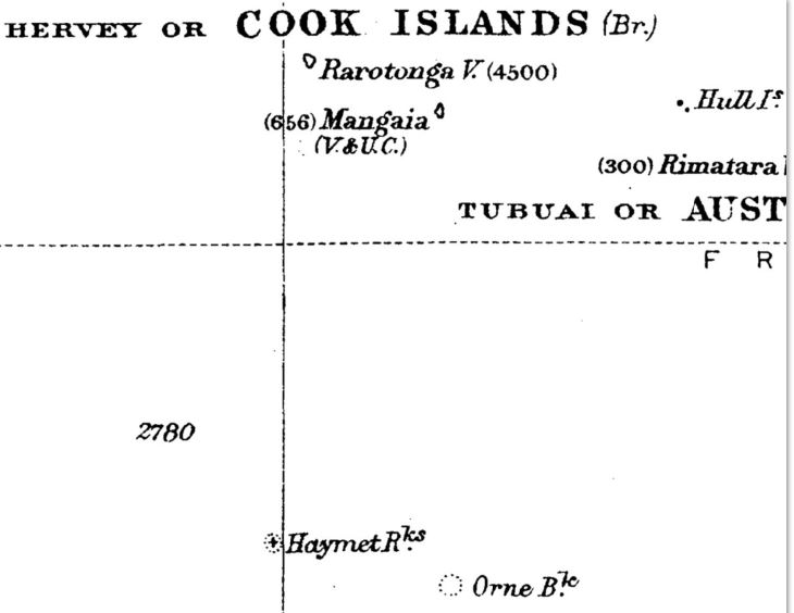
Haymet Rocks located south of Mangaia, a possible remnant of Tuanaki. (Source - R.W.Williamson: The Social and Political Systems of Central Polynesia, 1924, Vol. 1). 23032416
In 1897 the ethnologist S. Percy Smith was told by a Rarotongan ta’unga, Tamarua Metua, that “in ancient times communication was not infrequent between Rarotonga and Tuanaki”. In reply to questions about the great migration to New Zealand he said, “A canoe named ‘Raupo’ … left this island, but she went in another direction (to New Zealand) to Tuanaki.” Concerning another voyaging canoe, the Mamari, carrying the ancestors of Nga-Puhi, Tamarua said it “went to the same place in the direction of Tuanaki…”
Tamarua also claimed that “Tuanaki was supposed to lie south from Rarotonga, and that their ancestors used to visit the island. It took them two days and a night to reach it.”
The first written mention of Tuanaki appears in a letter from Taha’a written on 16 November 1825, by the missionary Reverend Robert Bourne, noting the approximate location of “an island called Tuanai, situated in about latitude 23 S and 158 W longitude – the mountains are of moderate height – it is populous and has an abundance of food but no hogs.” Bourne had obtained this information from an “East Indian” (i.e., a S. E. Asian), “living at Rimatara who touched there (at Tuanaki) some years ago on a vessel belonging to Port Jackson.”
In 1843, the Rev William Gill, stationed at Rarotonga, wrote that the mission “had heard much of this island (Tuanaki), and had taken a voyage of a week hoping to have seen it.” Describing it as “in our immediate vicinity” and lying “4 or 5 degrees Southeast of Rarotonga” it was “known by tradition in all the islands of our group, but yet undiscovered (by Europeans). It is asserted to be situated not more than two hundred miles to the south or south-west of Rarotonga, and is said to consist of three low islands, within one reef, and to be thickly inhabited….Two native sailors had seen the island at different times when on board vessels, one of whom had intercourse with the people. He said, that they exactly resembled the Mangaians in person, dress, and customs…”
In 1844 the Rev George Platt led a search for the island en route to Rarotonga from Rurutu but found nothing.
Later that year, William Gill undertook another search onboard the Samuel and Mary accompanied by the Rarotongan missionary Maretu. Sailing initially to Aitutaki, Gill interviewed an old man called ‘Soma’ (or Toma) who had visited Tuanaki in 1842. Maretu takes up the story in his autobiography – “on our arrival we found there a man named Soma, who had been ashore three months from a ship. He told us he had seen Tuanaki … ‘Two years have passed since I saw that island’. He had gone there via Rurutu. The Captain asked Soma to go inland and search for the Tuanaki people. ‘When I reached some way inland, I saw a house which was full of men – it was the house of the ariki, or high chief. The chief asked me, ‘Whence do you come? From Araura?’ I replied, ‘Yes!’ ‘Come inside the house!’ So I went inside; there were none but men there, no women, as they have a separate house. After I had sat down, the chief asked again, ‘Do you come from Araura,’ to which I replied, ‘I came from Araura’ – for that is their name for Aitutaki. ‘A! Where is the captain of your ship?’ I told him he was with the boat. ‘He is afraid, lest you should kill him!’ ‘We do not kill men; we only know how to dance and sing; we know nothing of war.’
Soma returned to inform his captain that the people were friendly. ‘The captain now went inland (with me) taking with him some scissors, axes, and head-dresses, and then entered the house, and presented the articles to the chief. The captain asked the chief his name; he replied, ‘Maeva-rua; Tuikura is my name from Rarotonga.’ The captain and I slept there that night, whilst the boat returned to the ship, taking some food, fowls, pigs, yams and bananas. We were six days ashore there.”
Mr. Gill asked Soma, “What are the people like?”. He replied: “They are exactly like us… Their water is scraped up in a bowl, or in a leaf of the giant taro. Their dialect is that of Mangaia, and they wear the tiputa (or poncho), and use the same kind of fans as at Mangaia…”
Asked for the direction to Tuanaki, Soma added “It takes one night (and day) to travel from Mangaia to Tuanaki. Take your bearings from Tau.” (Tau-ono or Matariki-tau-ono, the Pleaides). According to Gerald McCormack, of Cook Islands Natural Heritage Trust, “Tau rises a little north of East, so going towards it from Mangaia would take you to Îles Maria (Ngaruroto) which certainly fits Soma's description (of Tuanaki).”
In 1860 and again in 1861 searches for Tuanaki were made by Captain John Williams Jr and in 1870 by Captain Fowler of the missionary ship John Williams, without success.
Around this time (1870) Captain Nolan on his schooner Peri, trading in the islands, reported an island “very low at latitude 240 25’, longitude 1590 4’ but he did not go near it” (Crocombe, 1983; 148).
The following year, the 1871 edition of Findlay’s South Pacific Directory included mention of “Tuanahe (?) … an island announced as doubtful by Captain Hamond in lat. 260 30’S, long. 160025’W. It is called Tuanaka by Captain Gray, United States Consul at Tahiti, and placed by him in 25050’S, 1600 55’W.”
Further hearsay, suggestive of Tuanaki’s existence, was published by S. Percy Smith in his book Hawaiki: The Original Home of the Maori (1904) which includes reference to a recollection by the NZ Native Land Court judge, J. A. Wilson that “a trading vessel from Auckland used, at one time in the forties (1840s), to visit an island, the exact position of which was kept secret. But on a subsequent visit it had disappeared” – probably this was Tuanaki.” (Smith 1904; 212). He also notes a comment by Lieut. Col. Gudgeon, formerly Resident Commissioner at Rarotonga, that “Old John Mana-a-rangi had seen some of the people of Tuanaki. I do not think it disappeared more than seventy years ago.” Another NZ academic John McMillan Brown claimed in 1919 that “Mr Stephen Savage... told me that he knew a native of Tuanaki who died last year of the epidemic.”
Still another source, the son of a Captain who settled on Rarotonga in 1865 under the care of John Manarangi, recalled that “Manarangi told us the story (about Tuanaki) and the natives believed it. The early missionaries were of the same opinion.”
In addition, Elsdon Best in The Polynesian Voyager writes that “Colonel Gudgeon states that the Haymet Reef, situated south of Rarotonga, is supposed to represent, or be a part of, the lost isle of Tuanaki.” The geographer Patrick Nunn, writing in 2008, notes that “If Tuanaki became Haymet Rocks, then it appears to have been located, approximately, it must be admitted, at 260 S 1600 W.”
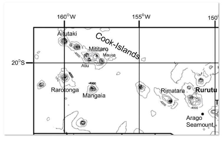
Map of the Austral-Cook Chain with bathymetry around Rurutu etc. Notice what appears to be a submerged seamount to the SE of Mangaia. (source - Takeshi Hanyu, et al., 2013). 23032417
Haymet Rocks is named after Captain Haymet, a Frenchman who lived and traded in Rarotonga but took to the sea again in charge of the Will Watch. Travelling from Auckland to Rarotonga in 1864, he came across the reef at 27°11′S 160°13′W. The US Navy Department’s “List of the Reported Dangers to Navigation in the Pacific Ocean’, published in 1866, carried Captain Haymet’s report that his schooner had “passed between two rocks about a quarter of a mile distant from each other with apparently but 7 or 8 feet of water over them and struck on the Northern one.” (Navy, 1866; 165)
According to Nunn, “There are other candidates for Tuanaki in the area, including Fabert Seamount (240 7’ S, 1580 33’ W) discovered in 1887, the summit of which lies about 120 metres below the ocean surface” (Nunn, 2008; 175). However, Gerald McCormack notes: “In 1986 the French Research Vessel Jean Charot surveying the area of Fabert Reef found nothing but discovered seamounts 1500m below the surface and 2° to the east”.
Without further evidence of Tuanaki, some of the 19th century Rarotongan missionaries became doubtful it ever existed. In 1856, William Gill wrote “That such an island exists there seems to be no doubt, and that it is comparatively near to the Hervey group is confirmed by all reports, but of its exact position we can gain no correct information.” (1856; 73). But some years later, in his autobiography, he wrote– “It has been found in after years, that the reported island (Tuanaki) was Easter Island due east of Rarotonga.” (1880; 138).
Another missionary Rev. William Wyatt Gill agreed, writing “The Easter Islanders claim to have come immediately from Rapa-iti, originally from Mangaia. From conversations with some of the Easter Islanders, I conclude their island to be the long and vainly-sought for island of Tuanaki, of which I have heard the old men speak, and after which the south-western part of Mangia is named.” (1876;26).
It’s unclear why these men reached this conclusion. Tuanaki was said to be an atoll unlike either Rapa-nui (Easter Island) or Rapa-iti (in the Australs) and as Gerald McCormack points out Rapa-nui is too far south to produce the foods that Soma mentioned and lies significantly farther from Mangaia than a day and night’s sail. Some connection between the Austral islands and Tuanaki has been suggested by Kami Papara, a Rimatara’s ta’unga who informed Gerald McCormack that Tuanaki lay off their southern coast and on a quiet night they could hear the drumming.
Wyatt Gill subsequently dismissed the whole idea of vanished islands, writing in Jottings from the Pacific, “During a residence of upwards of thirty years in the Pacific (1852 – 1883) I have not heard of the disappearance of a single island.” (1885; 264).
Some Mangaians were equally skeptical of Tuanaki’s existence, telling Maretu – “You’ll never see Tuanaki. You’ll come back with nothing.” Still, Maretu never lost faith in the island’s existence, regretting, to his final days, the mission’s failure to find and convert its people (Crocombe, 1983; 147, 202).
The inability of Rarotongans and Mangaians to accurately locate Tuanaki has been cited as proof that the island never existed. But, as seen in the case of Ngaruroto/Îles Maria, the Maukean people’s knowledge of that island’s location was quickly forgotten, within just a few generations.
The story of Tuanaki persisted throughout the twentieth century. When Frederick Christian was headmaster at Mangaia from 1919 – 21, he recorded local knowledge of Tuanaki as an “island midway between Rarotonga and Mangaia, said to have sunk about a hundred years ago.” And when the anthropologist Don Marshall interviewed Mangaians in the 1950s, he found that Tuanaki was known as both a place-name in the Mangaian puna Kei'ā, and as “The name of an island south of Rarotonga…, said to have been inhabited by a red-haired, bronze skinned people (some of who are still said to be living in the other Cook Islands) which has sunk into the sea; some Mangaians are said to have lived on this beautiful island.”
In 1952, the Pacific Islands Monthly continued the theme of Tuanaki descendants living in other Cook Islands claiming “A family living in Titikaveka claims direct descent from a Tuanaki man. Others claim that their great-grand parents had visited the island which was said to be “within sight of the mountains of Rarotonga.” (PIM, February 1952)
Modern technologies have, so far, remained unable or undeployed to locate the island. Marjorie Crocombe notes that in the 1950s, “the Calibration aircraft of the NZ Department of Civil Aviation tried again to locate the island … Nothing was found. In May 1974, the New Zealand DSIR ship Tangaroa discovered a shallow area of water and reef formation in the area” (Crocombe, 1983; 148).
In recent years three writers, the oceanographer Henry Stommel, the geographer and geologist Patrick Nunn and the historical geographer Raymond Ramsay have re-examined the evidence for Tuanaki’s former existence.
Ramsay concluded “There is no reasonable doubt that Tuanaki did exist and did cease to exist within a time span that can be roughly pinpointed” (1972; 215).
Henry Stommel, whom Nunn describes as “that most critical of modern lost island professionals” remained uncertain.
Nunn himself concluded “the island was in existence in the 1830s but had somehow vanished by 1844 when missionaries went searching for it.”
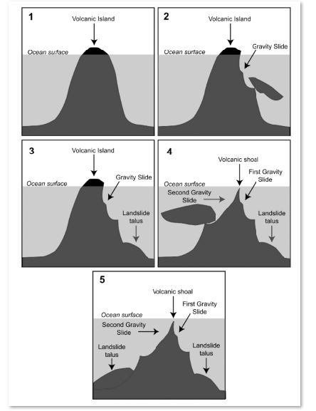
Diagram 1 - How a volcanic island can disappear - model explaining the disappearance of an island because of successive flank failures (Source – Nunn and Pastorizo; 2007; 154). 23032418
Nunn suggests that the island may have been undermined by successive failure of submarine volcanic flanks as shown in Diagram 1. Interestingly, two years after Nunn’s work was published, Mangaia suffered in April 2010 what appears to have been a small-scale episode of flank collapse on its southern coast, generating a significant local tsunami. This was investigated by Professor James Goff who noted “The occurrence of flank collapse and submarine slope failures … on Mangaia should not be considered surprising, since many of the other southern Cook Islands have experienced similar activity in the past.”
Goff also believes, “a flank collapse would seem to be the logical explanation” for the disappearance of Tuanaki if it ever existed.
However, Gerald McCormack is not so sure of flank collapse taking “an island down to more than 1000m below sea level…The highest seamount southeast of Mangaia is 1500m below. And while it shows the likelihood of slumping, removing 1500m is a stretch. Possible, but a stretch.” Goff agrees, but adds the rider that “possible, but a stretch undoubtedly happens from time to time.”
Such a dramatic flank collapse would have likely generated a tsunami, for which evidence may exist in sediments in makatea caves on the south coast of Mangaia. In time, as more geological and bathymetric or seabed surveys for this region are undertaken, more definite information on the Cooks ‘vanished islands’, real or imagined, may emerge.
Note – both Howard Henry and Gerald McCormack have researched Tuanaki and helped with corrections and suggestions. Any errors are mine. A full list of references is available from roderickdixon@gmail.com